Showing posts with label earthquakes. Show all posts

Jul 29, 2015

Did You Reassess Your Preparedness Level after the New Yorker Story?

West Coast Map Earthquake

The New Yorker published a story July 20th, 2015, in which they detailed the destruction a massive earthquake and subsequent tsunami would cause in areas of the Pacific Northwest. The story is called The Really Big One (Schulz, 2015).
The danger zone that the article is referring to lies just north of the San Andreas Fault line. It is known as the Cascadia subduction zone, and it runs for seven hundred miles off the coast of the Pacific Northwest, and ends near Vancouver Island Canada.
Continue Reading...

Jun 29, 2015

Helium is LEAKING from massive earthquake fault in LA raising fears 'big one' could be more devastating than thought

A huge fault in the Earth's crust near Los Angeles is leaking helium, researchers have found.
They say the unexpected find sheds new light on the Newport-Inglewood Fault Zone in the Los Angeles Basin.
It reveals the fault is far deeper than previously thought, and a quake would be far more devastating.
It follows a report from the U.S. Geological Survey has warned the risk of 'the big one' hitting California has increased dramatically. 
 Scroll down for video
The Newport–Inglewood Fault extends for 75 kilometers (47 mi) from Culver City southeast to Newport Beach at which point the fault trends east-southeast into the Pacific Ocean

NEWPORT-INGLEWOOD FAULT

The Newport–Inglewood Fault extends for 75 kilometers (47 mi) from Culver City southeast to Newport Beach at which point the fault trends east-southeast into the Pacific Ocean.
The fault can be seen on the Earth's surface as line of hills extending from Signal Hill to Culver City. 
The fault has a slip rate of approximately 0.6 millimeter/year (0.02 in/year) and is predicted to be capable of a 6.0–7.4 magnitude earthquake on the moment magnitude scale.
The fault was first identified after a 4.9 magnitude quake struck near Inglewood, California on June 21, 1920.
UC Santa Barbara geologist Jim Boles found evidence of helium leakage from the Earth's mantle along a 30-mile stretch of the Newport-Inglewood Fault Zone in the Los Angeles Basin.
He claims the results show that the Newport-Inglewood fault is deeper than scientists previously thought.
Using samples of casing gas from two dozen oil wells ranging from LA's Westside to Newport Beach in Orange County, Boles discovered that more than one-third of the sites show evidence of high levels of helium-3 (3He). 
'The results are unexpected for the area, because the LA Basin is different from where most mantle helium anomalies occur,' said Boles, professor emeritus in UCSB's Department of Earth Science.
'The Newport-Inglewood fault appears to sit on a 30-million-year-old subduction zone, so it is surprising that it maintains a significant pathway through the crust.'
Considered primordial, 3He is a vestige of the Big Bang, and its only terrestrial source is the mantle.
Boles's findings appear in Geochemistry, Geophysics, Geosystems (G-Cubed), an electronic journal of the American Geophysical Union and the Geochemical Society. 


When Boles and his co-authors analyzed the 24 gas samples, they found that high levels of 3He inversely correlate with carbon dioxide (CO2), which Boles noted acts as a carrier gas for 3He. 
An analysis showed that the CO2 was also from the mantle, confirming leakage from deep inside the Earth.
Blueschist found at the bottom of nearby deep wells indicates that the Newport-Inglewood fault is an ancient subduction zone - where two tectonic plates collide - even though its location is more than 40 miles west of the current plate boundary of the San Andreas Fault System. 
Found 20 miles down, blueschist is a metamorphic rock only revealed when regurgitated to the surface via geologic upheaval.
A scene from the movie San Andreas in which the fault triggers a devastating earthquake in LA, the largest in recorded history
The film sees devastation take over the city as everyone fights to escape the effects of the magnitude 9 quake
A geologic cross section of the Los Angeles Basin from the southwest to northeast. This profile intersects the Newport-Inglewood Fault Zone at Long Beach
'About 30 million years ago, the Pacific plate was colliding with the North American plate, which created a subduction zone at the Newport-Inglewood fault,' Boles explained. 
'Then somehow that intersection jumped clear over to the present San Andreas Fault, although how this occurred is really not known. 
'This paper shows that the mantle is leaking more at the Newport-Inglewood fault zone than at the San Andreas Fault, which is a new discovery.'
The study's findings contradict a scientific hypothesis that supports the existence of a major décollement — a low-angle thrust fault — below the surface of the LA Basin. 
'We show that the Newport-Inglewood fault is not only deep-seated but also directly or indirectly connected with the mantle,' Boles said.
The cylinders Jim Boles used to gather casing gas samples from oil wells along the Newport-Inglewood fault, where he found evidence of helium-3. 
'If the décollement existed, it would have to cross the Newport-Inglewood fault zone, which isn't likely,' he added. 
'Our findings indicate that the Newport-Inglewood fault is a lot more important than previously thought, but time will tell what the true importance of all this is.' 
Researchers analysed the latest data from the state's complex system of active geological faults, as well as new methods for translating these data into earthquake likelihoods.
The estimate for the likelihood that California will experience a magnitude 8 or larger earthquake in the next 30 years has increased from about 4.7% to about 7.0%, they say.
In the new study, the estimate for the likelihood that California will experience a magnitude 8 or larger earthquake in the next 30 years has increased from about 4.7% for UCERF2 to about 7.0% for UCERF3.

THE SAN ANDREAS FAULT

The San Andreas system in Northern California consists of five major branches with an overall length of about 1,25O miles. 
Experts say there is a 99 percent chance of a magnitude-6.7 earthquake or larger in the next 30 years in California because of the number of fault lines in the region.
The San Andreas Fault that forms the tectonic boundary between the Pacific Plate and the North American Plate is the biggest.
 'We are fortunate that seismic activity in California has been relatively low over the past century,' said Tom Jordan, Director of the Southern California Earthquake Center and a co-author of the study.
'But we know that tectonic forces are continually tightening the springs of the San Andreas fault system, making big quakes inevitable.
'The UCERF3 model provides our leaders and the public with improved information about what to expect, so that we can better prepare.'
The Third Uniform California Earthquake Rupture Forecast, or UCERF3, improves upon previous models by incorporating the latest data on the state's complex system of active geological faults, as well as new methods for translating these data into earthquake likelihoods.
The study confirms many previous findings, sheds new light on how the future earthquakes will likely be distributed across the state and estimates how big those earthquakes might be.
Compared to the previous assessment issued in 2008, UCERF2, the estimated rate of earthquakes around magnitude 6.7, the size of the destructive 1994 Northridge earthquake, has gone down by about 30 percent. 
The expected frequency of such events statewide has dropped from an average of one per 4.8 years to about one per 6.3 years.
However, in the new study, the estimate for the likelihood that California will experience a magnitude 8 or larger earthquake in the next 30 years has increased from about 4.7% for UCERF2 to about 7.0% for UCERF3.
'The new likelihoods are due to the inclusion of possible multi-fault ruptures, where earthquakes are no longer confined to separate, individual faults, but can occasionally rupture multiple faults simultaneously,' said lead author and USGS scientist Ned Field. 

THE 1906 EARTHQUAKE

The M 7.8 San Francisco earthquake of 19O6 struck the coast at 5.12 am on 18 April 18. Devastating fires lasting several days broke out in the city. 
As a result about 3,OOO people died and over 8O percent of San Francisco was destroyed.
The earthquake and resulting fire are remembered as one of the worst natural disasters in the history of the US alongside the Galveston Hurricane of 19OO and Hurricane Katrina in 2OO5.
People walk through the rubble following an earthquake in San Francisco on April 18, 1906. On April 17, 1906, San Francisco was cosmopolitan enough to host Enrico Caruso in "Carmen" and so financially flushed it ranked fourth among American cities in raising money to help victims of a volcano in Italy.  A day later, San Francisco was pleading for help itself after a giant earthquake struck along the San Andreas fault.
People walk through the rubble following an earthquake in San Francisco on April 18, 1906. On April 17, 1906, San Francisco was cosmopolitan enough to host Enrico Caruso in 'Carmen' and so financially flushed it ranked fourth among American cities in raising money to help victims of a volcano in Italy. A day later, San Francisco was pleading for help itself after a giant earthquake struck along the San Andreas fault.
'This is a significant advancement in terms of representing a broader range of earthquakes throughout California's complex fault system.'
Two kinds of scientific models are used to inform decisions of how to safeguard against earthquake losses: an Earthquake Rupture Forecast, which indicates where and when the Earth might slip along the state's many faults, and a Ground Motion Prediction model, which estimates the ground shaking given one of the fault ruptures. 
The UCERF3 model is of the first kind, and is the latest earthquake-rupture forecast for California. It was developed and reviewed by dozens of leading scientific experts from the fields of seismology, geology, geodesy, paleoseismology, earthquake physics and earthquake engineering.
Lucy Jones, a USGS seismologist and Los angeles Mayor Eric Garcetti's adviser on earthquakes, tweeted Tuesday about the randomness of big quakes. 
'This new science doesn't change the bottom line for emergency managers,' she wrote. 
'Which one happens in our lifetimes is a random subset.'


Read more: http://www.dailymail.co.uk/sciencetech/article-3143818/Helium-LEAKING-massive-earthquake-fault-LA-raising-fears-big-one-devastating-thought.html#ixzz3eVtgo4Mg 

May 23, 2015

Former NASA & White House Advisor Warns of Earthquakes, Volcanic Eruptions and New Madrid Event!

The world is seeing a severe increase in both the frequency and severity of geological activities – Earthquakes, tsunamis, volcanic eruptions and sinkholes.  With events like the Nepal earthquake, Indonesian and Chile volcanic eruptions, and other major events, the internet is a frenzy.  Theories go from fracking, to geoengineering (HAARP), to Bible Revelation and MORE.  However, this former consultant to NASA & the White House has the answer, warns of possible future events like a New Madrid earthquake, and shares it all with me in this exclusive interview!  

Feb 23, 2015

The New Madrid Earthquake That Will Divide The United States In Half

New Madrid Fault Earthquake Zone

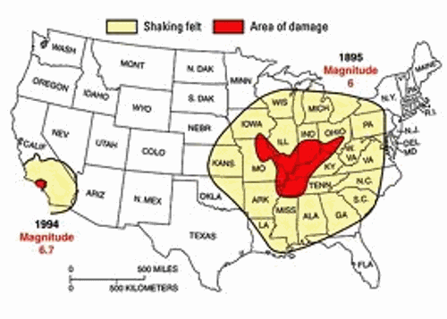
Once upon a time, North America almost divided along a very deep subsurface rift.  Today, that rift system and the faults associated with it are known as the New Madrid fault zone.  This fault zone is six times larger than the San Andreas fault zone in California and it covers portions of Illinois, Indiana, Missouri, Arkansas, Kentucky, Tennessee and Mississippi.  Back in 1811 and 1812, four of the largest earthquakes in U.S. history struck that area of the country.  The movement of the ground was so powerful that it changed the course of the Mississippi River and it rang church bells in Boston, Massachusetts.  So could such an earthquake (or worse) strike today?  Well, last year the U.S. Geological Survey released a report that warned that the New Madrid fault zone has the “potential for larger and more powerful quakes than previously thought“, and the USGS also admits that the number of significant earthquakes in the middle part of the country has more than quintupled in recent years.  We also know that the U.S. government and large corporations are so concerned about the potential for a major New Madrid earthquake that they have held major exercises that simulate one.  Scientists tell us that it is just a matter of time until another superquake hits the region, and personally I am one of the millions of Americans that believe that we will eventually see a New Madrid earthquake that will divide the United States in half.  That is one of the reasons why I included a New Madrid earthquake in my novel.  But others are skeptical.  They point out that we have not seen a truly devastating earthquake in that region for more than 200 years.  So why be concerned about one now?
What everyone can agree on is that there is an area of significant geological weakness under the New Madrid fault zone.  This area of weakness formed when the continents were breaking up.  The rift that formed did not end up splitting the North American continent at that time, but the area of weakness remains.  The following comes from Wikipedia
The faults responsible for the New Madrid Seismic Zone are embedded in a subsurface geological feature known as the Reelfoot Rift that formed during the breakup of the supercontinent Rodinia in the Neoproterozoic Era (about 750 million years ago). The resulting rift system failed to split the continent, but has remained as an aulacogen (a scar or zone of weakness) deep underground, and its ancient faults appear to have made the Earth’s crust in the New Madrid area mechanically weaker than much of the rest of North America.
This relative weakness is important, because it would allow the relatively small east-west compressive forces associated with the continuing continental drift of the North American plate to reactivate old faults around New Madrid, making the area unusually prone to earthquakes in spite of it being far from the nearest tectonic plate boundary.
And indeed, there have been some awesome earthquakes in this region throughout history.
Back in 1811 and 1812, there were four earthquakes along the New Madrid fault zone there were so immensely powerful that they are still talked about today.
Those earthquakes opened deep fissures in the ground, caused the Mississippi River to run backwards, and were reportedly felt more than 1,000 miles away.  It is said that the stench of fire and brimstone hung in the air for months afterwards.
The most powerful of this series of quakes was on December 16th, 1811.  The following is one description of what happened on that day…
This powerful earthquake was felt widely over the entire eastern United States. People were awakened by the shaking in New York City, Washington, D.C., and Charleston, S.C. Perceptible ground shaking was in the range of one to three minutes depending upon the observer’s location. The ground motions were described as “most alarming and frightening” in places like Nashville, Tenn., and Louisville, Ky. Reports also describe houses and other structures being severely shaken, with many chimneys knocked down. In the epicentral area the ground surface was described as being in great convulsion, with sand and water ejected tens of feet into the air — a process called liquefaction.
But there have also been others times throughout history when we have seen a major earthquake along the New Madrid fault.
For example, according to scientists there is evidence of other superquakes in the distant past
Geological evidence indicates that two such super-earthquakes happened twice in the past 1,200 years: the first some time between 800 and 1000 A.D., and the second between 1300 and 1600 A.D.
And now earthquake activity in the central portion of the nation is increasing again.
As I noted above, the USGS says that the frequency of earthquakes in the central and eastern portions of the United States has more than quintupled in recent years.  And the USGS has now gone so far as to point out the relationship between human activity and the increase in earthquakes.  The following comes from an article done by the U.S. Geological Survey
The number of earthquakes has increased dramatically over the past few years within the central and eastern United States. Nearly 450 earthquakes magnitude 3.0 and larger occurred in the four years from 2010-2013, over 100 per year on average, compared with an average rate of 20 earthquakes per year observed from 1970-2000.
This increase in earthquakes prompts two important questions: Are they natural, or man-made? And what should be done in the future as we address the causes and consequences of these events to reduce associated risks? USGS scientists have been analyzing the changes in the rate of earthquakes as well as the likely causes, and they have some answers.
USGS scientists have found that at some locations the increase in seismicity coincides with the injection of wastewater in deep disposal wells. Much of this wastewater is a byproduct of oil and gas production and is routinely disposed of by injection into wells specifically designed for this purpose.
So what would happen if a major earthquake did strike the New Madrid fault zone?
This is something that scientists have studied.  If a magnitude 7.7 earthquake hit the region today, thousands would die, hundreds of thousands of buildings would be damaged, and the economic losses would be measured in the hundreds of billions of dollars.  The following comes from Wikipedia
In October 2009, a team composed of University of Illinois and Virginia Tech researchers headed by Amr S. Elnashai, funded by the Federal Emergency Management Agency (FEMA), considered a scenario where all three segments of the New Madrid fault ruptured simultaneously with a total earthquake magnitude of 7.7. The report found that there would be significant damage in the eight states studied – Alabama, Arkansas, Illinois, Indiana, Kentucky, Mississippi, Missouri and Tennessee – with the probability of additional damage in states farther from the NMSZ. Tennessee, Arkansas, and Missouri would be most severely impacted, and the cities of Memphis, Tennessee and St. Louis, Missouri would be severely damaged. The report estimated 86,000 casualties, including 3,500 fatalities; 715,000 damaged buildings; and 7.2 million people displaced, with 2 million of those seeking shelter, primarily due to the lack of utility services. Direct economic losses, according to the report, would be at least $300 billion.
But remember, that study only considered a magnitude 7.7 earthquake.
If we had an earthquake of magnitude 8 or magnitude 9, we could be talking about an earthquake many, many times more powerful.
It is also important to note that there are 15 nuclear reactors along the New Madrid fault zone.  In the event of a major New Madrid earthquake, we could be looking at Fukushima times 15.
Of course most Americans are completely oblivious to all of this.  In fact, most Americans don’t even know what the New Madrid fault zone is or where it is located.
But there are people in the government that are very aware of this threat.  In fact, the federal government considered it important enough to hold a major five day simulation known as “National Level Exercise 11″ just a few years ago…
In May, the federal government simulated an earthquake so massive, it killed 100,000 Midwesterners instantly, and forced more than 7 million people out of their homes. At the time, National Level Exercise 11 went largely unnoticed; the scenario seemed too far-fetched — states like Illinois and Missouri are in the middle of a tectonic plate, not at the edge of one. A major quake happens there once every several generations.

National Level Exercise 11, or NLE 11, was, in essence, a replay of a disaster that happened 200 years earlier. On Dec. 16, 1811, a magnitude 7.7 earthquake hit the New Madrid fault line, which lies on the border region of Illinois, Indiana, Missouri, Arkansas, Kentucky, Tennessee and Mississippi. It’s by far the largest earthquake ever to strike the United States east of the Rockies. Up to 129,000 square kilometers [50,000 square miles] were hit with “raised or sunken lands, fissures, sinks, sand blows, and large landslides,” according to the U.S. Geological Service. “Huge waves on the Mississippi River overwhelmed many boats and washed others high onto the shore. High banks caved and collapsed into the river; sand bars and points of islands gave way; whole islands disappeared.” People as far away as New York City were awakened by the shaking.
More quakes, of a similar size, followed. But the loss of life was minimal: Not too many people lived in the area at the time. Today, there are more than 15 million people living in the quake zone. If a similar quake hit, “7.2 million people could be displaced, with 2 million seeking temporary shelter” in the first three days, FEMA Associate Adminsitrator William Carwile told a Congressional panel in 2010. “Direct economic losses for the eight states could total nearly $300 billion, while indirect losses at least twice that amount.”
And major corporations are also concerned about what could happen.
For example, in a previous article I noted that Wal-Mart had “participated in an exercise” that simulated a major earthquake in the New Madrid fault zone…
Buried in a Wall Street Journal article from about a week ago was a startling piece of information.  According to a Wal-Mart executive, Wal-Mart “participated in an exercise to prepare for an earthquake on the New Madrid fault line” earlier this summer.
Nobody knows when it is going to happen.
But this is a real threat.
And if we do see a magnitude 9.0 earthquake or greater, we could be talking about a continent changing event.

http://endoftheamericandream.com/archives/the-new-madrid-earthquake-that-will-divide-the-united-states-in-half

Nov 29, 2014

Earthquake Preparedness: It Is Never Too Late To Start

Earthquake Preparedness

According to the United States Geological Society (USGS), close to 2 million earthquakes occur every year in the world. However, some of the quakes are so slight that they are not detectable without sophisticated equipment.
It may seem like earthquakes are occurring more often, but better detection equipment and the fact people are living in more remote areas may create this belief. Earthquakes of course occur in regions that are not populated and so they do go undetected, unless there is seismic detection equipment located in the area (USGS, 2014).
Typically, earthquakes will occur along the edge of the oceanic and continental plates but of course, they can essentially occur anywhere. They strike without notice, and depending on the magnitude, the destruction can be devastating resulting in loss of life and extensive property damage.
Those living near a coastal region can also experience a tsunami because of an earthquake. Large tidal waves caused by earthquakes can destroy entire towns and cities creating untold damage to the coastal regions. Normally there is some notice of a pending tsunami but you cannot rely on being notified.
  • Stay inside the home or building when an earthquake occurs. People are killed and injured by falling debris from buildings, from downed live power lines and from sinkholes in the streets. People also become injured from trying to evacuate buildings during an earthquake.
  • Never enter any damaged building with a lit candle because of possible gas leaks.
  • Monitor for tsunami warnings and evacuate as soon as the possibility of one becomes clear
To determine your risk for an earthquake visit the following: https://www.fema.gov/earthquake/earthquake-hazard-maps
Prepping Your Home for an Earthquake
Hazards from an earthquake can include mud/landslides, tsunamis, collapsing structures, falling trees and light poles/street signs, collapsing tunnels and overpasses, sinkholes in streets and from fires and explosions because of ruptured gas lines and from damage to electrical wiring. These mentioned of course are not the only hazards but they are the typical ones.
Inside your home, you can be hurt from the structure collapsing, from falling dressers, mirrors wall mounted televisions, brick or stone fireplaces, appliances that tip over, falling dishes/pots and pans out of cupboards and from falling canned goods, and from fires occurring because of gas leaks or from damaged wiring.
In areas where earthquakes occur in this country, commercial and private structures must meet certain standards so the structure can withstand a certain magnitude earthquake. This does not mean however that your home or commercial structure will not receive damage but the likelihood of the entire structure collapsing down upon you is dramatically lessened.
In countries where the infrastructure is poor or non-existent and there are no building codes the death toll from earthquakes is considerably higher.
Check with the local code enforcement and/or city-building inspectors to determine if your home is up to code. Even though it may not seem like it, inside of your home during and immediately after an earthquake is the safest place.
Getting Started
First, you need a safe room that everyone gathers in when an earthquake occurs. The room should have a load-bearing wall (s). What is a load-bearing wall? A load-bearing wall (or bearing wall) is a wall that bears a load resting upon it by conducting its weight to a foundation structure.
You will need a stout table to get under for protection from falling debris, and the table can be pushed up against the load-bearing wall. The room should be big enough so if there is a fireplace you can be far enough away from it so any falling brick or stone would not pose a threat.
Televisions should be anchored to the wall if they are on a stand and in many cases, they will come with a strap so you can anchor them to a stud. Wall mounted televisions are not recommended nor are hanging chandeliers. Emergency supplies should be kept in the room for immediate use. You can also store football or bicycle helmets for children and adults for head protection.
1.) It is important that you know how to shut off the main supply of gas to the home. If an earthquake occurs, you want to stop the gas from flowing into the home and leaking through ruptured gas lines running to the appliances.
You can also have special gas valves installed on your meter that will automatically shut off if there is a tremor. The shut off valves are sometimes called “earthquake actuated gas shutoff valves” and in some counties or cities, the valves may be required.
If you do not have an automatic shutoff valve, you can use a pipe wrench or adjustable Crescent Wrench.
2.) Shut off the main breaker that supplies electricity to the entire home.
3.) Use metal or suitable nylon straps to anchor your hot water tank to wall studs to prevent tip over which can cause injury and water damage. Additionally the hot water tank could be a source of emergency water so protect the source.
4.) Upright refrigerator/freezers must be strapped to the wall studs to prevent tip over. Washers, dryers, and dishwashers typically would not pose a threat. However, stackable washers and dryers would pose a threat so make sure they are anchored properly. Microwaves mounted over the stove as well as wall-mounted ovens could pose a threat, so make sure they are anchored to the studs as well.
5.) Dish cupboards should have solid doors with latches that would prevent the dishes from spilling out. Pot and pan racks must be anchored properly as well.
6.) Pay particular attention to bedrooms. You do not want any object falling on a sleeping person. Bureaus/dressers and armoires must be far enough away from the bed or anchored properly. Televisions must be anchored and any wall-mounted televisions must be far enough way so if they do fall they do not strike the bed. The same applies to any brick or stone fireplaces.
7.) Sideboards or curio cabinets must be anchored to wall studs, and the cabinets should have latches that prevent the doors from falling open.
9.) Surprising enough even builders will at times only anchor overhead lights to the sheetrock if it is ½ sheetrock. You need to make sure any overhead lighting is anchored to the ceiling joists and this means you will have to get into the attic to check. You can nail a 2×4 between the joists to anchor any ceiling lights to or use metal banding designed specifically for this purpose.
10.) Keep all hazardous/toxic chemical on the lowest shelf in the home.  In the garage at floor, level inside a metal cabinet with a latch on the door is the recommended storage method. Spilled chemicals can cause death or injury to those inside the home.
Emergency Supplies
As with any crisis there are certain items you will need regardless of the calamity so your home preparedness kit will have what you need, with possibly a few exceptions.
  • You may need crowbars, firefighter axes, handsaws and sledgehammers for extraction from damaged building or for rescue operations
  • Head mounted battery operated lights and remember any flame can cause an explosion from leaking gas
  • Heavy rope such as climbing rope for extraction and rescue
  • Heavy brooms and shovels for cleanup as well as large rubbish barrels
  • Quality respirators because there will be airborne contaminates in the air from insulation, plaster, sheetrock and so on, as well as, contaminates from spilled chemicals
Sources:

Oct 15, 2014

Four Sections of the San Andreas Fault are ‘Locked’ and Building Up Pressure

SFEq06_01
1906 San Francisco earthquake. Image credit: CA.gov

A new report from the Bulletin of the Seismological Society of America (BSSA) has highlighted four sections of the San Andreas fault that are locked in place and building up pressure.

Fault creep describes the slight slips, and the release of small amounts of pressure that build up on fault lines. Without the creep that most faults exhibit, the pressure builds and builds until there is a major earthquake when the ‘stuck’ rocks suddenly move and the pressure is released.

The BSSA study has highlighted four areas where creep is not currently occurring. From Science Daily:
 
This study estimates how much creep occurs on each section of the San Andreas Fault system in Northern California. Enough creep on a fault can diminish the potential size of its next earthquake rupture.
“The extent of fault creep, and therefore locking, controls the size and timing of large earthquakes on the Northern San Andreas Fault system,” said James Lienkaemper, a co-author of the study and research geophysicist at U.S. Geological Survey (USGS). “The extent of creep on some fault sections is not yet well determined, making our first priority to study the urban sections of the San Andreas, which is directly beneath millions of Bay Area residents.”
Understanding the amount and extent of fault creep directly impacts seismic hazard assessments for the region. The San Andreas Fault system in Northern California consists of five major branches that combine for a total length of approximately 1250 miles. Sixty percent of the fault system releases energy through fault creep, ranging from 0.1 to 25.1 mm (.004 to 1 inch) per year, and about 28 percent remains locked at depth, according to the authors.
Monitoring of creep on Bay Area faults has expanded in recent years. The alignment array measurements made by the San Francisco State University Creep Project and recently expanded GPS station networks provide the primary data on surface creep, which the authors used to estimate the average depth of creep for each fault segment. Where available, details of past ruptures of individual faults, unearthed in previous earthhquakes.
According to the study, four faults have accumulated sufficient strain to produce a major earthquake. Three creeping faults have large locked areas (less than 1 mm or .04 inches of creep per year) that have not ruptured in a major earthquake of at least magnitude 6.7 since the reporting of earthquakes by local inhabitants: Rodgers Creek, northern Calaveras and southern Green Valley. The southern Hayward fault, which produced a magnitude 6.8 earthquake in 1868, is now approaching its mean recurrence time based on paleoseismic studies.
 
The authors also estimate three faults appear to be nearing or have exceeded their mean recurrence time and have accumulated sufficient strain to produce large earthquakes: the Hayward (M 6.8), Rodgers Creek (M 7.1) and Green Valley (M 7.1).
 
“The San Andreas Fault and its two other large branches, the Hayward and Northern Calaveras, have been quiet for decades. This study offers a good reminder to prepare today for the next major earthquake,” said Lienkaemper.
 
The San Andreas Fault was first identified in 1895. It is about 800 miles long and it has been responsible for several major earthquakes in California. In 1906 The San Francisco ruptured causing a 7.8 magnitude quake that killed around 3000 people and injured thousands more. In 1952 12 lives were lost in the Kern County ‘quake and in 1971 there were 65 deaths in the San Fernando earthquake. 1989 saw the Loma Prieta earthquake cause 63 deaths and damage running into billions of dollars.
 
The Northridge earthquake of 1994 was the first major quake to occur directly under an urban area since the 1933 Long Beach earthquake. The Northridge quake caused the strongest ground movement forces ever recorded in an urban area in North America. Although no deaths resulted directly from the tremblor damage was widespread and the costs of repairing collapsed highways and damaged homes and infrastructure ran into billions of dollars.
 
October 16th sees the ‘Great California Shake-out‘ event which stages drills and provides information to Californians on how to deal with earthquakes and their aftermath.
You can learn more about earthquake safety and preparedness here and here.
Sources:

Delivered by The Daily Sheeple

Aug 27, 2014

Simulation: New Madrid Quake Would Kill 100,000 Instantly; Displace 7 Million

If you live in and around Illinois, Indiana, Missouri, Arkansas, Kentucky, Tennessee and Mississippi you might want to consider the following – then again, if you’re reading this web site you probably already have:
New Madrid Quake
 
In May, the federal government simulated an earthquake so massive, it killed 100,000 Midwesterners instantly, and forced more than 7 million people out of their homes. At the time, National Level Exercise 11 went largely unnoticed; the scenario seemed too far-fetched — states like Illinois and Missouri are in the middle of a tectonic plate, not at the edge of one. A major quake happens there once every several generations.

National Level Exercise 11, or NLE 11, was, in essence, a replay of a disaster that happened 200 years earlier. On Dec. 16, 1811, a magnitude 7.7 earthquake hit the New Madrid fault line, which lies on the border region of Illinois, Indiana, Missouri, Arkansas, Kentucky, Tennessee and Mississippi. It’s by far the largest earthquake ever to strike the United States east of the Rockies. Up to 129,000 square kilometers [50,000 square miles] were hit with “raised or sunken lands, fissures, sinks, sand blows, and large landslides,” according to the U.S. Geological Service. “Huge waves on the Mississippi River overwhelmed many boats and washed others high onto the shore. High banks caved and collapsed into the river; sand bars and points of islands gave way; whole islands disappeared.” People as far away as New York City were awakened by the shaking. 
More quakes, of a similar size, followed. But the loss of life was minimal: Not too many people lived in the area at the time. Today, there are more than 15 million people living in the quake zone. If a similar quake hit, “7.2 million people could be displaced, with 2 million seeking temporary shelter” in the first three days, FEMA Associate Adminsitrator William Carwile told a Congressional panel in 2010. “Direct economic losses for the eight states could total nearly $300 billion, while indirect losses at least twice that amount.”
Source: Wired Danger Room
Though there is debate over whether or not a New Madrid earthquake is due, the prudent thing to do would be for every individual and family to prepare. The Federal government will be capable of a very limited response, especially in a region-wide disaster on the scale of a 7.7 quake. This means that if it, or even a lower magnitude quake were to take place, individuals would be on their own, and it would be a long time before help arrived:
Electric power would go out, not for days, but for weeks and months in the four state region,” he said. “Municipal water systems, they all run on electricity, don’t they? Well, people are gonna get thirsty. You need water for firefighting, don’t you? Second, all gasoline pumps run on electric power. Same with diesel fuel. So in terms of road mobility, of getting the relief forces in, and evacuating people out — no gasoline? The cascading failures go on and on.
In such an event, there would likely be significant strain on the rest of the nation as well. It has also been postulated that a large enough quake in the region could potentially cause flooding for hundreds of miles, literally expanding the width of the Mississippi River and potentially submerging areas of Texas, Mississippi, and Louisiana.

In addition to the well known natural potential for a major earthquake in this area, oil drilling utilizing hydraulic fracturing, or fracking, has been active on a mass scale, theoretically increasing the likelihood of a major earthquake:
Canadian Geologist Jack Century crusades against induced seismicity from irresponsible drilling. In a 2009 speech before the Peace River Environmental Society, he provided a brief explanation of how fracking induces earthquakes, completely refuting industry denial that fracking causes quakes. Fracking induces not only micro- and mini-seismic actions that can compromise the integrity of well casings, but also large earthquakes registering on the order of 5 to 7 on the Richter Scale, resulting in human deaths.
Source: Activist Post
While quakes may be a normal occurrence in Arkansas and the surrounding region, recent earthquake data is alarming and may be the reason why the government has been performing simulations and drills:
When comparing Arkansas’ earthquake history with its drilling history, a causative correlation becomes obvious.
The entire 19th century saw 15 recorded earthquakes and none in the first decade of the new century. A total of 694 quakes rocked Arkansas in the 20th century. That number was surpassed in 2009-2010, with the bulk (483) occurring the last three months of 2010.
Source: Activist Post
It’s clear that the potential for a major event in this area is more likely now than at any time in the last 100 years.

FEMA and local emergency management personnel should be focusing their preparedness efforts directly on the individuals in these regions, advising those who live within the seismic zones that in an emergency, no one will be coming to assist, or response will be limited. Currently, the overwhelming focus of their efforts is direct response from government personnel.

Rather than “See Something, Say Something” DHS ads at local grocery stores and retail outlets, perhaps a better strategy would be to promote individual preparedness concepts such as asking people if they have a 30 day preparedness plan, and then going on to describe essential strategies in the event of a an earthquake emergency that include information such as:
  • Water and Food
  • Medical Supplies
  • Disaster Tools
  • Emergency Evacuations Plans
  • What to do when an earthquake strikes if you’re outside, in your home, or in your car
  • And, dealing with critical rescue response if a friend or family member has been trapped under debris
We urge those of our readers in these areas to learn more about personal earthquake response, as well as to coordinate efforts with friends and family outside of the seismic regions in the event you have to evacuate. This includes preparing yourself and family for making the evacuation journey on foot, bikes, or four wheel vehicles, as well as multiple pick-up locations where your contacts can meet you along your evacuation route and when (i.e. — within 3 days of quake we should be here, etc.).

http://www.bioprepper.com/2014/08/27/simulation-new-madrid-quake-would-kill-100000-instantly-displace-7-million/

Aug 24, 2014

Earthquake Rocks San Francisco: Widespread Power Outages

70+ people have been injured, and tens of thousands are without power after a 6.0 Magnitude Earthquake rocked the San Francisco area overnight.

The quake caused significant damage in California’s northern Bay Area, igniting fires, knocking out power to tens of thousands, and damaging buildings and roadways throughout the area. Gov. Jerry Brown declared a state of emergency for the Napa Valley area of California, which was the hardest-hit by the earthquake.

Damaged Building form today's Earthquake

The earthquake occurred almost 9 miles south of Napa Valley, hitting at around 3:20 am. The quake was large enough to be felt throughout the Bay Area, from Santa Cruz to Sonoma County.
Reported Damage:
  • 70+ People have been hospitalized
  • 50,000 are without water
  • 80 gas & waterlines have been ruptured
  • 50,000 homes in Bay Area are without power.
Bay Area Road
Bay Area Road ripped apart by the Quake
Roadway damage from Earthquake
Hwy 121/12 near Napa Valley Damaged by the overnight Earthquake
This is the largest earthquake to hit California since the 1989 Loma Prieta quake, and experts say there is a 10% chance that this could be a precursor to a larger quake – something known as a foreshock.

http://offgridsurvival.com/earthquake-rocks-san-francisco/

Aug 18, 2014

How California's extreme drought will lead to a wave of earthquakes

water

How California's extreme drought will lead to a wave of earthquakes


(NaturalNews) With about 60 percent of the state now limping through the worst categorical level of drought on record, California faces an unprecedented water crisis that, besides triggering shortages, stands to greatly influence the availability of fresh produce nationwide. And as far as its own residents and the residents of nearby states are concerned, there is an additional threat also waiting in the wings: the increased likelihood of earthquakes.

A new study published in the journal Nature raises some serious questions about the stability of California now that underground aquifers are plunging to record lows. All throughout the Central Valley, which grows most of the nation's lettuce, almonds and other produce, more water is being pumped out of the ground than is being put back in, a phenomenon that researchers say is causing the ground to shift.

According to a team of geologists led by Colin B. Amos from Western Washington University, the subterranean landscape beneath the earth, also known as the lithosphere, is literally separating from the land on top throughout California. The California Coast Ranges, the Tehachapi Mountains, and the southern Sierra Nevada, says TakePart's Chris Clarke, are rising by as much as three millimeters per year, or roughly an inch every 10 years.

A series of 500 GPS recorders carefully placed throughout the Central Valley and its surrounding mountains revealed that the water table throughout the area is rapidly dwindling. This means that the 176 billion-ton water load that normally holds down the lithosphere is becoming increasingly lighter, resulting in a land separation that, historically speaking, has made the ground more prone to seismic activity.

"Groundwater pumping unburdens the lithosphere," said William Hammond, a geologist at the University of Nevada and co-author of the study, as quoted by TakePart. "When you pump that much groundwater, the load gets taken away and the landscape essentially bounces up. The Sierra Nevada is rising more quickly as a result of groundwater pumping in the Great Valley."

2011 earthquake in Spain caused by water overdrafts, say scientists

Back in 2011, a 5.2-magnitude earthquake that rocked Lorca, Spain, killing 10 people and causing extensive infrastructure damage, was found to have been caused by the overdraft of water from local aquifers. A cohort of researchers determined that, based on the fault slip pattern and movement of land at the surface, changes in aquifer volumes were the most likely cause of the quake.

"The area of fault slip correlates well with the pattern of positive Coulomb stress change that we calculate to result from the extraction of groundwater in a nearby basin aquifer," wrote the authors of a study published in the journal Nature Geoscience. "Our results imply that anthropogenic activities could influence how and when earthquakes occur."

In the Central Valley, a similar phenomenon has been documented in relation to when the most water is drawn from underground aquifers to nourish crops. In the late summer and early fall, according to geologists, the Parkfield section of the infamous San Andreas Fault system typically experiences increased seismic activity exceeding 1.25 magnitude or higher, which is also the time when the most water is drawn.

"That seasonal change means loading and unloading on the lithosphere," added Hammond. "The earth flexes up and down, and small earthquakes seem to respond to that."

Sources for this article include:

http://www.takepart.com

http://www.nature.com

http://www.bbc.com

http://science.naturalnews.com

 http://www.naturalnews.com/046503_drought_earthquakes_California.html#ixzz3AjiZmuz8