
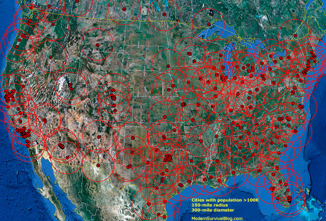
I built the following map of the United States (shown below) identifying the 276 cities in the United States with populations greater than 100,000 people. I then drew a 300 mile diameter zone circled around each city (150 mile radius). Here’s why…
I chose the 150 mile radius as a distance which in my estimation approximately represents ‘the Zombie hordes’ potential extension beyond the cities following SHTF collapse while in search of food, water, perceived safety and survival – all which is variable of course, depending on factors such as these:
The majority of the hordes, on average, will probably get no further than about 150 miles for some of the following reasons.
-most people will believe the government will save them
-most people have no plan for evacuation
-most people will not leave the cities and MSAs while they can, having nowhere to go
-most people have no survival kit, bug-out bag, 72-hour kit, a plan, etc..
-most people only have one-half tank of gas or less in their vehicle
-traffic jams will inhibit or block major routes
-most people do not know alternate routes out
-road blocks may impede travel
-inability to walk very far without major survival issues
-most people are badly out of physical shape
-most people are badly out of physical shape; difficulty on foot
-most people not prepared to survive without food at the grocery stores
-most people cannot build a fire, shelter, etc…
Here’s my logic regarding 150 miles based on gasoline in their vehicles’ gas tank.
How Far Will The Zombie Hordes Get?
There are two exceptions to mention regarding the validity of zombie hordes moving through the 300-mile diameter (150-mile radius) zones that you see on the map.
1. The map (horde circles) does not reflect the effects of the highway systems and significant roadways of travel. For example there are regions within some of the 300-mile-zones where there are no roads, or barely any at all. Since most of the horde will initially and primarily stick to the roads and highways, regions with no roads will be far less traveled.
2. Within some of the horde zones, there are geographical obstacles (mountains, forests, canyons, etc.) which most of the horde will not attempt to traverse.
The purpose of the map is to help identify your security risk based on where you live and to help to identify ‘safer’ regions within the USA. I’ve included cities on the southern border of Canada which are populated greater than 100,000 since this may affect some of the northern states of the U.S. although it’s doubtful that Canadians will head south to the United States during collapse.
Two interesting observations regarding east of the Mississippi…
1. Southern West Virginia has a clear region.
2. Much of Maine is clear.
By Ken Jogurstin
www.modernsurvivalblog.com
Wow. So you think this contributes to our safety to have this map? Are you serious?
ReplyDelete